Manaslu Circuit Trek
The Manaslu Circuit Trek is a 14-day circuit around Manaslu (8,163 m), the world's eighth-highest mountain, crossing the Larkya La Pass at 5,106 metres through one of the most remote and least visited trekking corridors in Nepal. The circuit is contained within the Manaslu Conservation Area, a protected zone that borders Tibet to the north and the Annapurna Conservation Area to the south.
The route starts from Soti Khola (700 m) after a full-day drive from Kathmandu and climbs progressively through the Budhi Gandaki River valley. The lower section passes through subtropical forest and Gurung villages. By Ghap (2,160 m) the valley narrows and the culture shifts abruptly to Tibetan Buddhist. Mani walls, prayer flags, and whitewashed chortens line the trail from here. The language in the teahouses above Ghap is a Tibetan dialect. The mountains loom closer with every day.
Samagaon (3,530 m) is the largest village in the Nubri Valley and the acclimatisation stop on this route. A rest day here allows an optional hike toward Birendra Lake (4,450 m) or toward the Manaslu Base Camp viewpoint, where the northeast face of Manaslu fills the western sky. Samagaon has a monastery — Pungyen Gompa — that dates to the 17th century and is still actively maintained by the local community.
From Samdo (3,875 m) the trail enters high desert terrain that resembles the Tibetan plateau. The villages become smaller and the landscape starker. Dharamsala (4,460 m), known locally as Larkya Phedi (base of Larkya La), is the last teahouse before the pass. The overnight stay here at 4,460 m is cold and acclimatisation is important.
The Larkya La crossing is the centrepiece of the circuit. The trail leaves Dharamsala before dawn at 04:00 to 05:00. The ascent through glaciated moraine and a final rocky section to the pass (5,106 m) takes 4 to 5 hours. The descent into Bimthang (3,720 m) is steep and long — 3 to 4 hours on loose moraine. Total crossing day: 7 to 9 hours. From the pass summit, Himlung Himal (7,126 m), Cheo Himal (6,820 m), and Manaslu's north face are all visible simultaneously.
Bimthang (3,720 m) in the upper Marsyangdi Valley is a high alpine meadow used as summer pasture by the village communities below. After Bimthang, the trail descends rapidly through Tilije and into Dharapani (1,960 m), where it meets the Annapurna Circuit trail and a road head. The Manaslu Circuit is complete.
The Restricted Area Permit required for this trek — a government regulation requiring a minimum of two trekkers and a licensed guide — limits the number of permits issued and keeps the route genuinely quiet. During peak season (October–November) you might see 30 to 50 other trekkers per day at most. On the Annapurna Circuit in the same season the number is in the thousands. This is what makes Manaslu worth the extra permit cost and the harder logistics.
The best months are October and November for post-monsoon clarity, and March and April for spring conditions. Larkya La is typically closed December through February due to heavy snowfall. The monsoon (June–September) is manageable on the lower trail but the pass becomes risky.
Upcoming departures.
| Start Date | End Date | Price / Person | Availability | |
|---|---|---|---|---|
| Oct 4, 2026 | Oct 17, 2026 | USD 1,590 | Filling Fast | Book Date |
| Oct 18, 2026 | Oct 31, 2026 | USD 1,590 | 5 spots left | Book Date |
| Nov 1, 2026 | Nov 14, 2026 | USD 1,490 | 7 spots left | Book Date |
| Apr 11, 2027 | Apr 24, 2027 | USD 1,550 | 8 spots left | Book Date |
| Oct 3, 2027 | Oct 16, 2027 | USD 1,650 | 8 spots left | Book Date |
6 moments you won't forget.
Larkya La Pass at 5,106 m
Larkya La is the highest point on the Manaslu Circuit and the defining day of the trek. The crossing leaves Dharamsala before dawn and ascends through glaciated moraine and rocky terrain to the pass summit at 5,106 metres. From the top, Himlung Himal (7,126 m), Cheo Himal (6,820 m), and the north face of Manaslu appear together in the western panorama. The descent into Bimthang takes 3 to 4 hours on steep moraine and rocky trail. The total crossing day covers 7 to 9 hours. Unlike Thorong La on the Annapurna Circuit, Larkya La sees very few groups — even in peak season you may see fewer than ten parties on pass day.
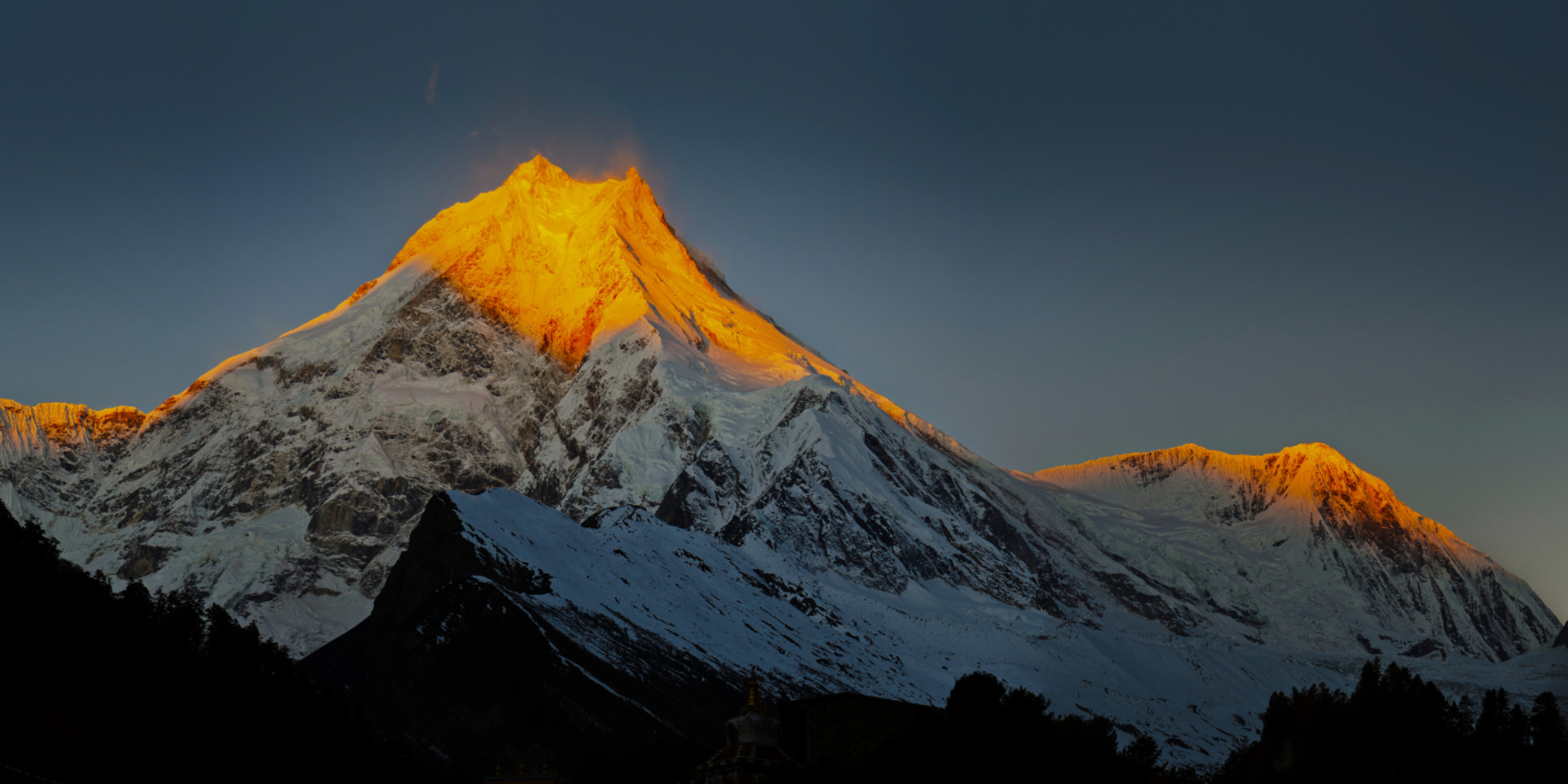
Manaslu — the world's eighth-highest peak
Manaslu (8,163 m) was first summited on 9 May 1956 by a Japanese expedition led by Toshio Imanishi and Gyalzen Norbu. The mountain has a distinctive pyramid form visible from many points on the circuit. The closest trekking approach is from Samagaon village, from which the northeast face of the mountain is less than 10 kilometres away. Birendra Lake (4,450 m) above Samagaon gives the most direct reflection of the northeast buttress. The word Manaslu derives from the Sanskrit manasa (mind or soul) — the mountain has been known as the 'Mountain of the Spirit' in Nepali literature since the 19th century.
Nubri Valley and Tibetan Buddhist culture
The upper Budhi Gandaki Valley — the Nubri Valley — has been home to Tibetan Buddhist communities for over 700 years. The residents are Tibetan in language, dress, and religious practice. The circuit passes through Lho, Samagaon, Sye, and Samdo — each village with at least one functioning monastery. Pungyen Gompa above Samagaon was built in the 17th century. The monks here speak the local Nubri dialect and Tibetan, and the monastery follows the Nyingma school of Tibetan Buddhism. The cultural distance between Samagaon and Pokhara is greater than the physical one.
The Restricted Area Permit — a quiet trail
The Manaslu Restricted Area Permit (MRAP) limits independent trekking on this route. All trekkers must hire a licensed guide, a requirement in place since 1991 to protect the cultural and natural environment of the Manaslu Conservation Area; the separate two-trekker minimum was dropped by Nepal's Department of Immigration in March 2026, so solo trekkers can now obtain the permit alone. The permit costs USD 100 per person per week during September to November, plus USD 15 per additional day. The practical effect in 2026 is a trail that sees perhaps 5,000 to 7,000 trekkers per year versus 80,000-100,000 on the Everest Base Camp trail and 60,000+ on the Annapurna Circuit.
Birendra Lake and the Manaslu north face
Birendra Lake (4,450 m) sits above Samagaon in a glacial bowl below the Manaslu Glacier. The lake is named after the late King Birendra of Nepal. At first light, the northeast face of Manaslu reflects in the still water of the lake before wind ripples the surface. The hike from Samagaon to Birendra Lake and back takes 4 to 5 hours on the acclimatisation day. Some groups continue above the lake toward the Manaslu Glacier viewpoint (4,800 m) for an even closer approach to the mountain.
Bimthang and the descent into the Marsyangdi
Bimthang (3,720 m) is a high alpine meadow in the upper Marsyangdi Valley used as summer pasture. After crossing Larkya La, arriving in Bimthang feels like re-entering the world — a green valley with yaks grazing and teahouses with real beds. From Bimthang the trail descends 1,760 metres over two days through Tilije to Dharapani, where the Annapurna Circuit road begins. The contrast between the high desert landscape above Larkya La and the lush Marsyangdi gorge below is one of the most dramatic altitude transitions in Nepal.
Trek in pictures.


Interactive circuit map.
The full 14 days-day circuit on a topographic map. Click any marker for details. Switch between Topo, Satellite, and Standard views using the layer control.
14 days days. Every detail planned.
Transparent, all-in pricing.
Included in your price
Not included
Trek altitude at a glance.
How hard is this trek?
Best time for the Manaslu Circuit Trek.
Weather on the Manaslu Circuit Trek.
Everything you need to know.
Open any card for in-depth notes on accommodation, food, altitude, permits, money and the small print that matters on the trail.
Your safety, planned in detail.
Altitude is the main risk on this trek. Here is exactly what we carry, who we call, and where the nearest help is at every stage of the route.
Common health risks
- •Larkya La crossing at 5,106m — AMS/HAPE/HACE risk peaks here
- •Frostbite on Larkya La in winter conditions or early/late season
- •Snow blindness — UV at altitude is intense
- •Cold injury at Larkya Phedi (basic lodge, exposed, cold)
- •Knee strain on the long descent to Bimthang and Tilije
- •Lost trail in snow — Larkya La can be invisible after fresh snow
- •Stomach upset from limited food options at higher altitudes
- •Hypothermia in tea houses without heated rooms
Our medical kit
- •Pulse oximeter (carried by guide, checks oxygen saturation)
- •Emergency oxygen cylinder (lead guide carries one above 4,000m)
- •Diamox (acetazolamide) for acute mountain sickness
- •Dexamethasone (HACE emergency use)
- •Nifedipine (HAPE emergency use)
- •Broad-spectrum antibiotics
- •Anti-diarrhoeal medication
- •Antihistamines
- •Strong painkillers (ibuprofen + paracetamol)
- •Wound dressings, blister kit, bandages
- + 4 more items carried by the lead guide
Travel insurance — required
- ✓Must cover trekking up to 5,200m (Larkya La is 5,106m)
- ✓Must include helicopter evacuation (USD 5,000+ coverage minimum)
- ✓Must include medical and emergency repatriation
- ✓We recommend World Nomads, True Traveller (UK), or Safety Wing — all cover Nepal trekking at altitude
- ✓Bring policy printout + emergency phone number to the pre-trek briefing
Nearest medical facilities
- •Sama Gaun (3,530m): Basic health post, sometimes staffed
- •Lho (3,180m): Basic first aid by gompa monks (informal but capable)
- •Besisahar (760m): Basic district hospital — 8 hours by jeep from trek exit
- •Kathmandu: CIWEC Travel Medicine Centre — specialist altitude care
- •Kathmandu: Norvic International Hospital — full surgical care
Emergency protocols
Manaslu is remote — helicopter response time is 90–120 minutes from Kathmandu. We carry satellite communicators on every trek. Pulse oximeter checks daily from Lho onward. On Larkya La crossing day, we have hard turn-back times: if any group member shows AMS symptoms by 09:00 at Dharmasala, we delay. We never rush the pass. Emergency oxygen carried; supplemental oxygen overnight if needed at Dharmasala (4,460m).
Helicopter evacuation
Helicopter evacuation from Manaslu region: USD 5,500–7,500 from Sama Gaun area to Kathmandu — fully reimbursable by qualifying insurance. From Dharmasala or Larkya La itself: USD 6,500–8,500 (more difficult landing). We coordinate with Simrik Air and Mountain Helicopters. Response time 90–120 minutes weather permitting; less if morning crews are available.
Nepal visa on arrival
Tourist visa-on-arrival at Kathmandu (Tribhuvan International) airport. USD 30 / 15 days, USD 50 / 30 days, USD 125 / 90 days. Bring 2 passport photos and USD cash. The arrival kiosk takes credit cards but with a 4–5% surcharge. Process takes 15–30 minutes on arrival depending on flight load.
From your front door to the trailhead.
Every leg of the journey, the mode of transport, the time it takes, and what's included. The complete picture from international arrival to trek start and back again.
Kathmandu hotel → Soti Khola
IncludedIncluded; long bumpy drive — bring snacks
Dharapani → Besisahar
IncludedIncluded
Besisahar → Kathmandu
IncludedIncluded
Helicopter return from Sama (optional)
+USD 580Avoids the long road exit
What to pack.
Plan Your Trek
Planning guides for the Manaslu Circuit Trek
Written by our guides, these cover the permits, altitude, timing, and kit you need before you go.
What trekkers say.
Common questions.
FitnessHow difficult is the Manaslu Circuit Trek compared to the Annapurna Circuit?+
The Manaslu Circuit is significantly harder than the standard Annapurna Circuit. Larkya La (5,106 m) is 300 metres higher than Thorong La (4,949 m). The trail is less maintained — some sections involve narrow gorge paths and loose terrain. Teahouses are simpler, especially above Ghap. The logistics are more complex with three permits required. On the positive side, the route is far less crowded and the cultural experience in the Nubri Valley is more authentic and undisturbed.
FitnessWhat fitness level do I need for the Manaslu Circuit?+
Strong fitness and previous Himalayan trekking experience to at least 4,000 m. You should have completed a multi-day trek in Nepal or a comparable high-altitude destination before attempting the Manaslu Circuit. The minimum benchmark: walk 10–15 km per day with a 7–8 kg daypack on consecutive days for 12 days without significant soreness. Larkya La crossing day (7–9 hours at 4,460–5,106 m) is the hardest single day and requires sustained aerobic capacity at altitude.
HealthWhat is the altitude sickness risk on the Manaslu Circuit?+
Moderate to high risk above 4,000 m. The acclimatisation schedule is built into the 14-day itinerary with a rest day at Samagaon (3,530 m) and a short approach day to Dharamsala (4,460 m). AMS can still occur despite following the schedule. Our guides check SpO2 every evening above 4,000 m and descend any trekker showing two or more symptoms immediately. Diamox (acetazolamide) is strongly recommended — consult your doctor before departure.
PlanningWhat permits are required and how much do they cost?+
Three permits are required: (1) Manaslu Restricted Area Permit (MRAP): USD 100 per person per week for September–November, plus USD 15 per additional day. For a 14-day October trek: approximately USD 215 per person. (2) Manaslu Conservation Area Permit (MCAP): NPR 3,000 (approximately USD 22) per person. (3) Annapurna Conservation Area Permit (ACAP): NPR 3,000 (approximately USD 22) per person, for the Dharapani–Besi Sahar section. All three permits are included in your package price and arranged by us in Kathmandu before departure.
PlanningWhy does this trek require a guide? Can I trek independently?+
No. The Manaslu Restricted Area Permit requires a licensed guide and a minimum group of two trekkers — it has been a requirement since the circuit opened in 1991. This is separate from the 2023 general Nepal guide regulation. You cannot obtain the MRAP without a registered guide. This is not a formality — the Larkya La crossing involves genuine remoteness and altitude risk that makes a competent guide essential rather than optional.
PlanningWhat is the best time of year for the Manaslu Circuit?+
October is the best single month — post-monsoon clarity, Larkya La in optimal condition, and comfortable daytime temperatures. November is nearly as good and noticeably less crowded, but Dharamsala reaches -15°C at night by mid-November. March and April are the best spring months — good views and manageable pass conditions, with spring snow on the upper approach requiring crampons in some years. Larkya La is effectively closed from December to mid-March due to heavy snowfall and avalanche risk.
PlanningHow do I get to the Manaslu Circuit trailhead?+
The trailhead is at Soti Khola (700 m), approximately 7 to 8 hours from Kathmandu by 4WD vehicle. The drive covers 170 km on the Prithvi Highway to Arughat and then unpaved road to Soti Khola. Private vehicle is included in the package. The circuit ends at Besi Sahar, which is connected to Kathmandu by paved road in 6 to 7 hours — a significantly smoother drive than the approach.
PlanningWhat should I budget for personal spending on the trail?+
Budget NPR 25,000–40,000 (USD 185–300) for 14 days. There are no ATMs on the Manaslu Circuit — withdraw all cash in Kathmandu. Hot showers: NPR 300–500 (upper camps). Wi-Fi: NPR 200–400/day (limited and slow above Lho). Soft drinks and beer: NPR 300–600 (increasingly expensive at altitude). Personal snacks for the Larkya La day: carry from Kathmandu or Samagaon market.
FoodWhat is the food like on the Manaslu Circuit?+
Good in the lower section, simpler in the upper. Below Ghap: standard teahouse fare — dal bhat, noodles, pasta, eggs. Above Ghap and through the Nubri Valley: Tibetan-influenced menus add tsampa (roasted barley flour), buckwheat noodles, and Tibetan butter tea. Dal bhat remains available throughout. The teahouses at Samagaon are the best on the upper route. Above Samdo the menus simplify further. Carry adequate snacks for the Larkya La crossing day — there is no food on the pass.
SafetyWhat are the conditions on the Larkya La crossing day?+
The crossing departs Dharamsala (4,460 m) at 04:00–05:00 in the dark. Temperature at departure: -5 to -15°C depending on month. The ascent takes 4 to 5 hours to the pass (5,106 m). The glaciated sections on the approach are manageable with microspikes under normal autumn conditions; crampons may be needed in spring or after fresh snowfall. Wind at the pass can be severe — have your warmest layer accessible. The descent to Bimthang takes 3 to 4 hours on steep loose terrain. Total crossing day: 7 to 9 hours. This is the most demanding day of the trek.
SafetyWhat happens if the Larkya La is closed due to weather?+
The guide assesses conditions via radio contact at 03:30 on the crossing day. If the pass is unsafe — fresh heavy snow, high wind, or icing beyond safe levels — the group waits at Dharamsala for 24 hours and reassesses. If still impassable, options include: (1) returning to Samagaon and exiting via the Buri Gandaki route (the same way you entered); (2) helicopter evacuation from Samagaon if the season is ending. In 10 years of operating on this route, we have had to abort due to weather on 3 occasions — all in late November.
InsuranceWhat travel insurance do I need?+
Travel insurance must cover trekking to 5,500 m and helicopter evacuation. This is a mandatory booking requirement. The Manaslu region has helicopter landing zones at Samagaon (3,530 m) and Bimthang (3,720 m). Evacuation to Kathmandu costs USD 4,000–7,000. Most Nepal-specific adventure insurance policies (World Nomads Adventure, Battleface, or Global Rescue) cover this route. Verify that your policy covers the Manaslu Restricted Area specifically — some standard policies exclude restricted zones.
Built different. On purpose.
Named lead guide before you book
Every booking is paired with a TAAN Class-A licensed guide with specific Manaslu Circuit experience. Name, photo, licence number, and WhatsApp contact shared at confirmation. The Manaslu Restricted Area Permit requires this guide to be registered — we handle all permit documentation.
Private trek, your group only
We never combine groups. Your party sets the pace. The Restricted Area Permit requires a minimum of two trekkers — solo travellers are matched only with a companion they have confirmed in advance.
All permits included, arranged in Kathmandu
The Manaslu Restricted Area Permit (MRAP), Manaslu Conservation Area Permit (MCAP), and Annapurna Conservation Area Permit (ACAP) — all three are included in your package price and arranged before departure. No paperwork surprises on Day 2.
Strict altitude protocol
SpO2 readings every evening above 4,000 m. Emergency oxygen cylinder carried on all Larkya La crossing days. Any trekker showing two or more AMS symptoms is descended immediately. The guide carries evacuation contacts for the Manaslu region — helicopter landing zones exist at Samagaon and Bimthang.


